VIENNA
INTERNATIONAL AIRPORT GUIDE 
Airport facilities located at each Vienna VIE airport terminalAirport transfers, taxis and public transport to Vienna VIE airportVienna VIE airport map and Vienna area map
Book a hotel near Vienna VIE airport
GETTING THERE
GETTING FROM
AT THE AIRPORT

Vienna International Airport Maps and Directions

Vienna International Airport Map

Vienna International Airport Map


Vienna Area Map

Vienna Area Map


Driving Directions

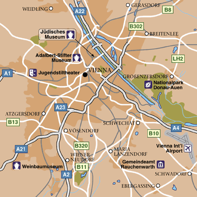
The easiest route to the Vienna International Airport is the A4 Airport Motorway. The motorway exit marked Flughafen, which means Airport, leads directly to the Airport's Terminal. The Vienna International Airport is also accessible via the B9 road.

From the airport the A4 motorway is the usual route taken by drivers proceeding towards the centre.

From the airport

Proceed towards the A4 motorway
Look for the 'Zentrum' (Centre) signs
Proceed towards the centre
Nearing the centre, the road reaches a junction
Drivers who proceed, as it were, straight across the junction, reach the B227 highway
The B227, a busy highway, runs along the Donaukanal, which is a branch of the Danube river
Many convenient routes may be accessed from the B227 Drivers may reach the centre by following signs for 'Zentrum' (Centre)

Found this useful? Why not share it with your friends...

Featured Hotels
     
1.5mi from airport
More Info »
     
4.0mi from airport
More Info »
     
4.7mi from airport
More Info »

BOOK FLIGHTS
CAR RENTAL
HOTELS

Email News

Sign up to receive the latest offers

Sign up »


Please note: The term Vienna International Airport VIE as well as all associated graphics, logos, and/or other trademarks, tradenames or copyrights are the property of the Vienna Airport authority and are used herein for factual descriptive purposes only. We are in no way associated with or authorized by the Vienna Airport authority and neither that entity nor any of its affiliates have licensed or endorsed us.