Newark Liberty International Airport Maps and Directions
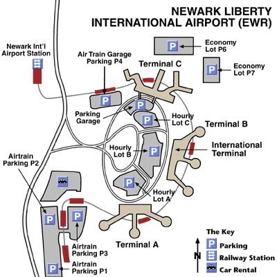
Newark Liberty International Airport Map
Newark Area Map

Maps and Directions
Newark Liberty International Airport is an extremely convenient airport to get in and out of. There are four principal routes by which to reach the airport.
US 1 & 9 runs roughly parallel to Newark Bay and the Hudson River, passing the airport on its way. The Airport Exit is signposted.
The NJ Turnpike (Interstate 95) goes roughly north-south through New Jersey and passes the airport at Exits 13A and 14.
Interstate 78 runs out of Manhattan and passes the airport on its way west. The Airport Exit is signposted.
NJ Route 22 runs through much of New Jersey, and has an airport exit.
Featured Hotels